Becoming Trash Scientists
This blog contains a lot of personal reflections about this trip down the Missouri. It has given us an opportunity to share aspects of living on the river and our deepening relationship with her.
But first and foremost, we are on this river to become trash scientists.
The product of this journey is an evolving database about trash on the Missouri: where it tends to accumulate, what patterns in density are there in relation to population centers, where are there historic and recent dumps, how are trash densities different on different stretches of the river? Basically: How trashed is the Big Muddy?
What better way to answer that question than to get out on this river?
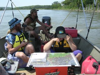 As our boats move downstream, each boat scouts a bank of the river. The crews on board scan the shore with binoculars while the boat pilot checks out the big picture. The conversation is, admittedly, a little boring:
Scout: “Is that a log or a hot water heater?”
Pilot: “I can’t tell. Let’s go check it out” (Boat swings behind wing dike. An electric whine as pilot tilts boat motor. A heron spreads its wings and vacates the area with an annoyed squawk.)
Scout (squinting through binocs): “It’s a hot water heater. Can you get in there?”
(Pilot shrugs, and Scout moves to the bow of the boat, probing the depth of the water with a canoe paddle as the boat moves to shore. As they land, Scout hops ashore, takes a digital photo of the heater, marks the point on handheld GPS unit, and approaches the appliance with a spray paint can.)
As our first week progressed, we kept coming up with more questions. Where are these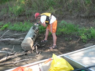 refrigerators coming from? How far do they travel? Finally, Charlotte Overby came up with the idea of spray-painting the river mile, date, and MRR on the backside of appliances. We know that high water will lift many of these huge objects again, sending them further downstream. We are hoping that, either in river clean-ups or by talking to people who spend time on the river, we’ll find out where some of these things end up and how long it takes them to move.
Each of those points that are GPSed, from a single refrigerator to a local dump site, are recorded separately on our data sheet. In addition, each mile on the river gets rated for the trash density and what kind of trash there is.
This is the scale:
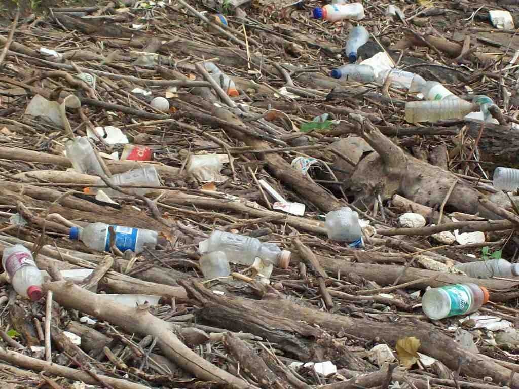
0 Clean to rare small trash
1 Scattered small trash
2 Small trash scattered & occasionally in concentrations
3 Like 2 but with occasional large trash
4 Frequent concentrations of trash, scattered large trash
5 Freq. concentrations,large trash &/or dumps
Again, more scintillating conversation:
Scout: “What do you think, a 2?”
Pilot: “I don’t know. There wasn’t much small stuff, but there were those barrels and that refrigerator and that boat access was pretty trashed. I think it’d be a 3”
Scout: “I agree.” (bends over data sheet and scribbles entry: “3 barrels, refrigerator, small trash at boat access, less small trash rest of the mile”)
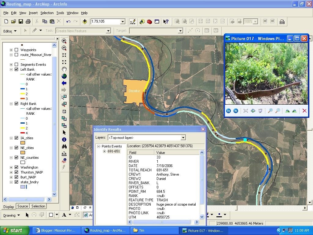
All of this data collected during the day, including photos, comments, trash ratings and GPS points get entered into our laptop “Betty” each night around the campfire. Dan is the data entry guy. His presence right there on the river makes the whole thing work better, and any questions he has on someone’s rating or comments get answered as the data goes in.
The data is entered into spreadsheets that are linked to an ARC-GIS map of the Missouri River. With software donated by the St. Charles office of ESRI, Tim Nigh, Dan Belshe and Kim Horton (of Mo-RAP) created a linkable route file following the channel of the river. Once the data is entered, users can click on any point on the river, and find out what the trash rating and any comments for that stretch is. Any point files or photos show up as a star, and can be accessed by a click.
The major innovation that Dan, Tim and Kim developed is a color-coded line that follows each bank of the river. “Zero” trash ratings show up as a cool blue, and the colors range from yellow to orange to red as you move up the scale.

As you zoom out from the map, the patterns become obvious. On the upper reaches of the river, small trash tends to collect on the inside of the river bends. At each population center, there is a flash of orange or red, as more trash ends up on the banks. Depending on the size of the city, the higher ratings often continue downstream.
For big cities, such as Omaha, there are often pulses of trash downstream, possibly showing where high water events have dropped trash as river levels crested and fell. At points where the river widens on a sharp bend, there are often larger accumulations of trash. Some communities show an obvious dedication to cleaning up their banks, while other places are more neglected.
So what do we do with this information?
Some of these maps are already being used. Vicki Richmond is working the “West Coast” of the Missouri River, planning our fall clean-ups in Omaha, Atchison and Sugar Creek (see our website www.riverrelief.org for specifics). She’s been whipping the maps out in meetings, showing visibly to our clean-up partners what we will be accomplishing on those weekends. They are already proving useful in coming up with strategies for getting people out on the river and getting the trash out of there.
We will be working on getting maps to other communities and government agencies along the river. If you have an interest in cleaning up your stretch of the Missouri, contact us so we can get the info to you. We won’t be able to clean every stretch of the Missouri ourselves, but by working with YOU, our community of fellow river lovers, we hope to make a dent in changing the way people view this wonderful resource.
Thanks to a donation from ESRI, the designers and distributers of the ARC software that we used for these maps, we will work toward getting these maps online, making the information accessible to everyone along the river.
Also, we will be using these maps as educational tools, showing children how the plastic bottles and tires that end up in their streams will travel and collect further downstream on the Big Muddy. That we all live both upstream and downstream, and the only ones that can make a difference in the quality of our rivers are US and it all starts in our backyards.
Please contact us if you have comments, questions or requests for information. Or just to let us know that you want to play a part in our mission to clean-up the Missouri River.
Missouri River Relief
P.O. Box 463
Columbia, MO 65205
(573) 443-0292
email: riverrelief@riverrelief.org
website: www.riverrelief.org

 As our boats move downstream, each boat scouts a bank of the river. The crews on board scan the shore with binoculars while the boat pilot checks out the big picture. The conversation is, admittedly, a little boring:
  refrigerators coming from? How far do they travel? Finally, Charlotte Overby came up with the idea of spray-painting the river mile, date, and MRR on the backside of appliances. We know that high water will lift many of these huge objects again, sending them further downstream. We are hoping that, either in river clean-ups or by talking to people who spend time on the river, we’ll find out where some of these things end up and how long it takes them to move.